IDS - International DORIS Service
 
IDS - International DORIS Service
  • IDS
    • Section content
    • Quick reference list
    • Organization
      • About IDS
      • Terms of Reference
      • Structure
      • Governing Board
      • Central Bureau
      • Analysis coordination
      • Analysis Centers
      • Combination Center
      • Data Centers
      • Working Groups
      • Associate Members
    • Meeting calendars
      • IDS Meetings
      • Meetings relevant for IDS
      • Other Calendars
    • Contacts & links
      • Contacts
      • Links
      • Directory
    • Gallery
  • Network & Stations
    • Section content
    • Network browser (sitelogs)
    • Maps
    • Network on Google Earth
    •  Network viewer Network viewer
    •  Station position times series Station position times series
  • Missions & System
    • Section content
    •  The DORIS technique The DORIS technique
    • Missions
    • Satellites in orbit
    •  Orbit residuals time series Orbit residuals time series
  • Data & Products
    • Section content
    • Tables of Data & Products
    • Data structure and formats
    • Information & DC organization
    • Central Bureau https
    •  CDDIS https CDDIS https
    •  IGN ftp://doris.ign.fr/pub/doris/ IGN ftp://doris.ign.fr/pub/doris/
  • User corner
    • Section content
    • Table of system events
    • Day convertor
    •  Network viewer Network viewer
    •  Plot tools Plot tools
      • Station position
      • Position residuals
      • Orbit residuals
      • Combination parameters
      • Earth Orientation Parameters
    • Applications
    • Combination Center
      • Activity & Products
      • Cumulative solution
      • DPOD
      • Contributions to ITRF
    • About DORIS/RINEX format
  • Resources
    • Section content
    • List of the documentation
    • Outreach material
    • Technical documents
    • Articles
      • DORIS bibliography
      • Citation
    • IDS publications
      • Newsletter
      • IDS Activity Reports
    • Presentations
      • Presentations at IDS meetings
      • IDS-related presentations
      • OSTST POD sessions
      • Other publications
    • IDS documents
      • Minutes IDS GB meetings
      • Other IDS documents
      • Mails
    • FAQ
  1. Home
  2. Resources
  3. Technical documents
  4. Network
  5. Maps

Maps

Maps

Here is a selection of maps of the DORIS network.

sites | colocations | satellite tracks | stations visibilities


DORIS sites

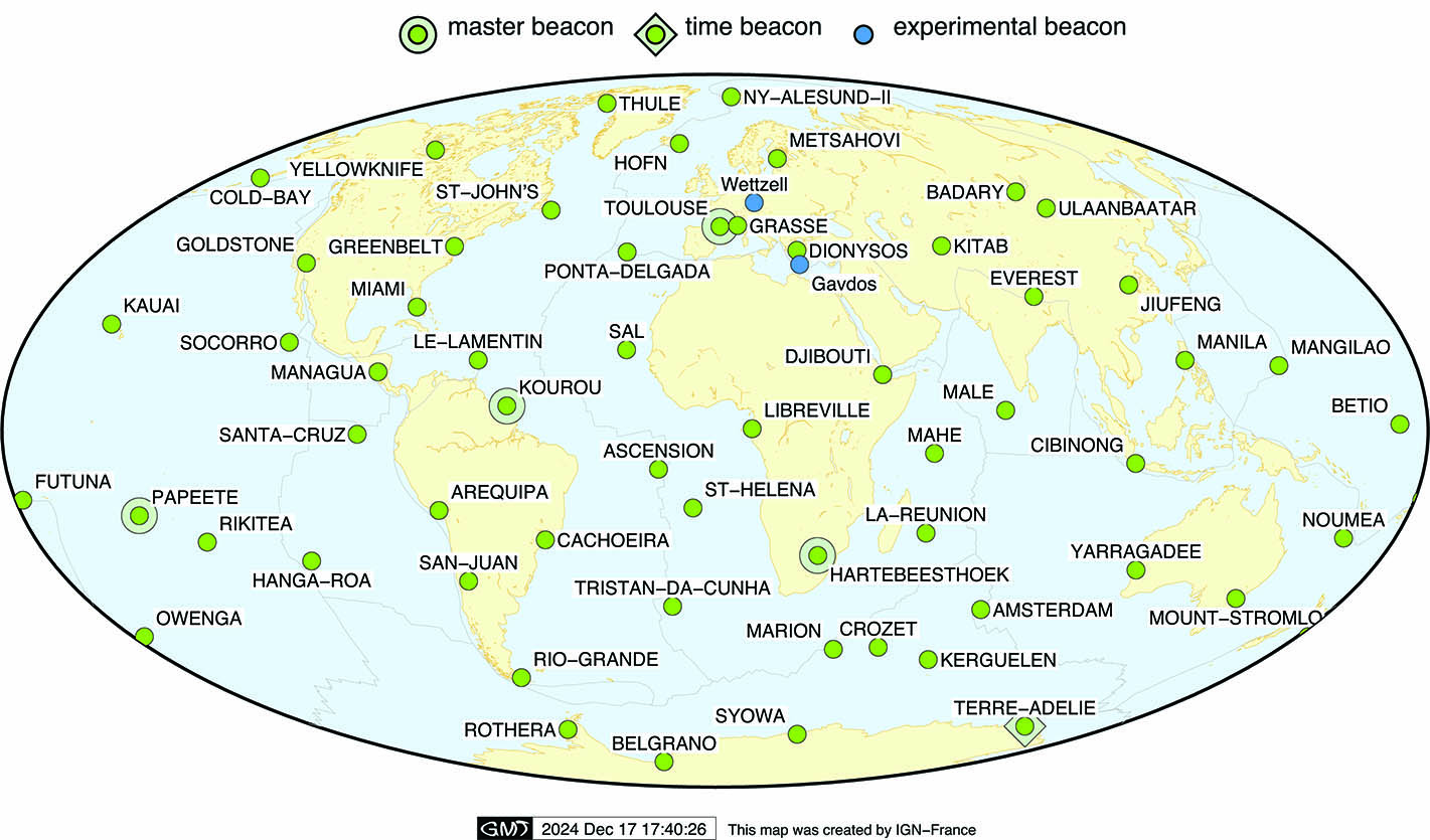
 Map of the current DORIS network
 Current DORIS network


 DORIS sites (as of December 2024)
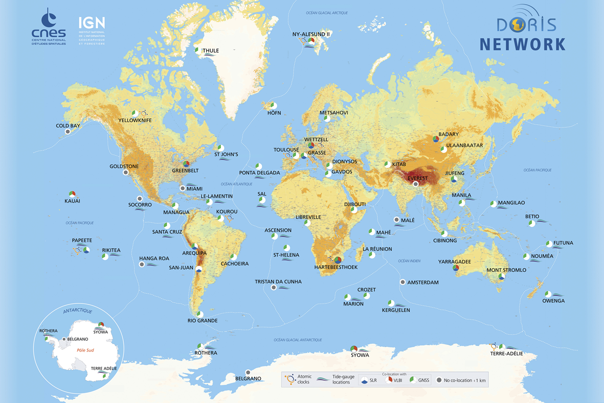
 DORIS permanent network


 DORIS network 2020
 DORIS network 2020


 Horizontal displacement of the DORIS stations (Moreaux et al., 2016)
 Horizontal displacement of the DORIS stations


DORIS colocations


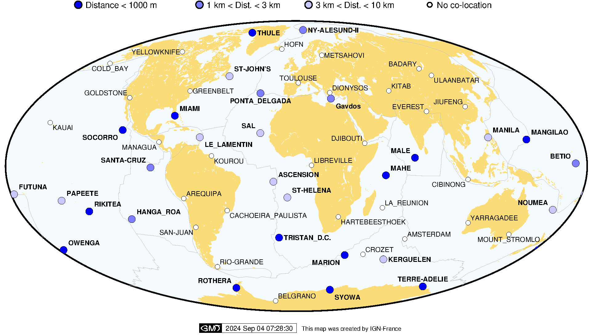
 DORIS stations co-located with other IERS techniques and tide-gauges (as of Sep. 2024)
 colocation IERS TG Sep2024


 DORIS and tide-gauges colocations (as of Sep. 2024)
 colocation Tide Gauge Sep2024


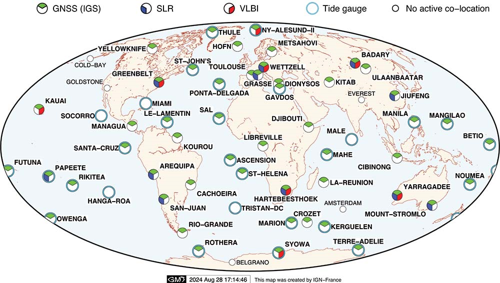
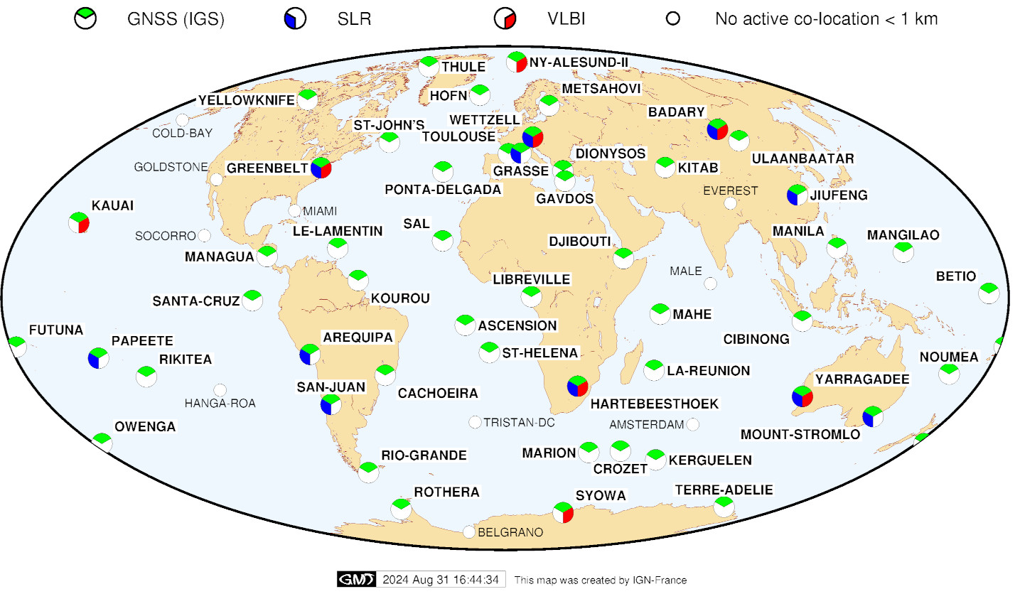
DORIS stations co-located with other techniques (VLBI, SLR, GNSS) (as of Sep. 2024)

See the evolution from Jan. 1993 to Nov. 2016


colocation IERS Sep2024


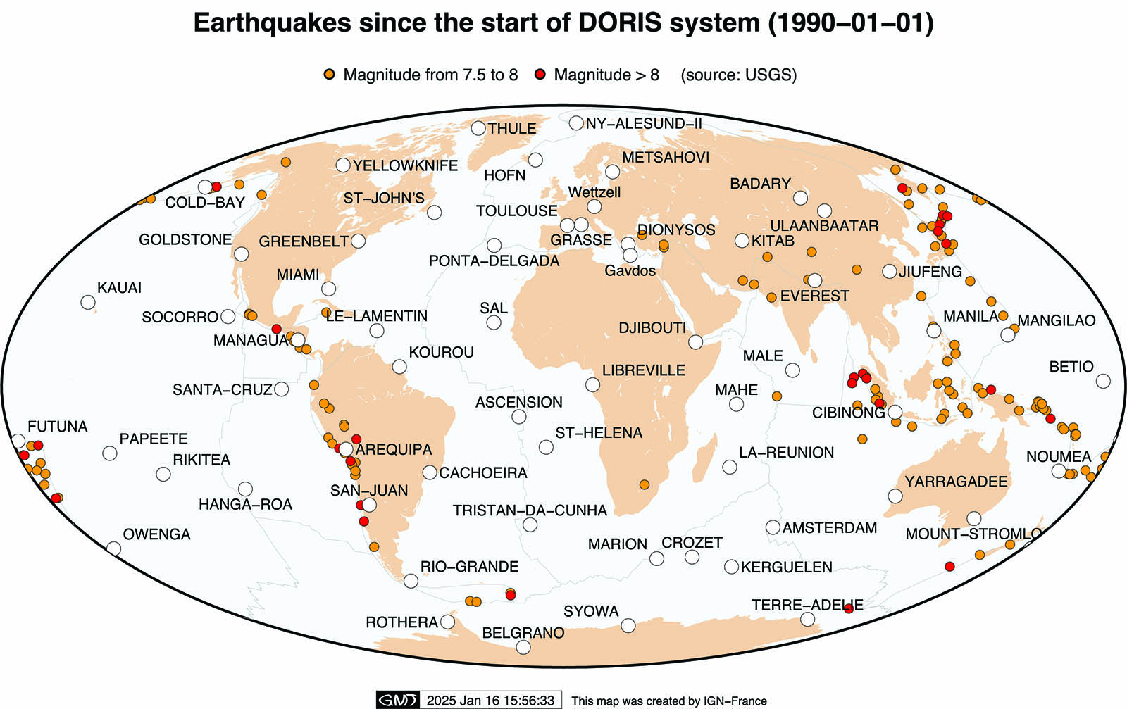
 DORIS network and Earthquakes since 1990 (as of Jan. 2025)
colocation Earthquake Jan2025


Satellite tracks

for 1 day (from 23/01/2025 14h TAI  to 24/01/2025 15h TAI)

legend

 Sentinel-6A: 66 deg. inclination (1336 km altitude)

inclination 66deg Sentinel6A

 Swot: 77 deg. inclination (~890 km altitude)

inclination 77deg SWOT

 Cryosat-2: 92 deg. inclination  (~700 km altitude)

inclination 92deg CryoSat2

 Sentinel-3B: 98 deg. inclination (~800 km altitude)

inclination 98deg Sentinel3B


DORIS stations visibilities, elevation 5°

for 1 day (from 23/01/2025 14h TAI  to 24/01/2025 15h TAI)

legend

 Cryosat-2:  ~700 km altitude (92 deg. inclination)

visibility circles 700km CryoSat2

 Sentinel-3B: ~800 km altitude (98 deg. inclination)

visibility circles 800km Sentinel3B

 Swot: ~890 km altitude (77 deg. inclination)

visibility circles 890km SWOT

 Sentinel-6A: 1336 km altitude (66 deg. inclination)

visibility circles 1336km Sentinel6A


Details
Last Updated: 13 February 2025
  • Section content
  • List of the documentation
  • Outreach material
  • Technical documents
  • Articles
    • DORIS bibliography
    • Citation
  • IDS publications
    • Newsletter
    • IDS Activity Reports
  • Presentations
    • Presentations at IDS meetings
    • IDS-related presentations
    • OSTST POD sessions
    • Other publications
  • IDS documents
    • Minutes IDS GB meetings
    • Other IDS documents
    • Mails
  • FAQ
Feed Entries

Discover IDS

  • Organization
  • Table of Data & Products
  • Bibliography
  • Newsletter
  • IDS video channel
  • Presentations at IDS meetings
  • Technical documents
  • Activity reports

Discover DORIS

  • The DORIS technique (AVISO+ website)
  • The satellites
  • The network
  • The stations (sitelogs)
  • Network on Google Earth

DORIS system monitoring

  • Table of system events
  • Visualize products time series
  • POE statistics
  • Network viewer
ICSU-WDS
ICSU-WDS
ICSU-WDS


logo cnes

Site Map |  Contact |  Citation |  Mails |  FAQ |  Glossary
Personal Data Protection Policy |  Legal Notice
Copyright © 1999-2025 CNES-CLS. All Rights Reserved.