IDS - International DORIS Service
 
IDS - International DORIS Service
  • IDS
    • Section content
    • Quick reference list
    • Organization
      • About IDS
      • Terms of Reference
      • Structure
      • Governing Board
      • Central Bureau
      • Analysis coordination
      • Analysis Centers
      • Combination Center
      • Data Centers
      • Working Groups
      • Associate Members
    • Meeting calendars
      • IDS Meetings
      • Meetings relevant for IDS
      • Other Calendars
    • Contacts & links
      • Contacts
      • Links
      • Directory
    • Gallery
  • Network & Stations
    • Section content
    • Network browser (sitelogs)
    • Maps
    • Network on Google Earth
    •  Network viewer Network viewer
    •  Station position times series Station position times series
  • Missions & System
    • Section content
    •  The DORIS technique The DORIS technique
    • Missions
    • Satellites in orbit
    •  Orbit residuals time series Orbit residuals time series
  • Data & Products
    • Section content
    • Tables of Data & Products
    • Data structure and formats
    • Information & DC organization
    • Central Bureau https
    •  CDDIS https CDDIS https
    •  IGN ftp://doris.ign.fr/pub/doris/ IGN ftp://doris.ign.fr/pub/doris/
  • User corner
    • Section content
    • Table of system events
    • Day convertor
    •  Network viewer Network viewer
    •  Plot tools Plot tools
      • Station position
      • Position residuals
      • Orbit residuals
      • Combination parameters
      • Earth Orientation Parameters
    • Applications
    • Combination Center
      • Activity & Products
      • Cumulative solution
      • DPOD
      • Contributions to ITRF
    • About DORIS/RINEX format
  • Resources
    • Section content
    • List of the documentation
    • Outreach material
    • Technical documents
    • Articles
      • DORIS bibliography
      • Citation
    • IDS publications
      • Newsletter
      • IDS Activity Reports
    • Presentations
      • Presentations at IDS meetings
      • IDS-related presentations
      • OSTST POD sessions
      • Other publications
    • IDS documents
      • Minutes IDS GB meetings
      • Other IDS documents
      • Mails
    • FAQ
  1. Home
  2. User corner
  3. Section content
  4. Analysis coordination
  5. Documents

Documents

Jason Postlaunch Satellite Characteristics for POD activities

Jason Postlaunch Satellite Characteristics for POD activities

Satellite reference system

The reference axes for Jason are similar in orientation to those of TOPEX/Poseidon. The X axis is along the satellite's main direction, pointing from the attachment ring towards the radiometer antenna. The Y axis is transverse, along the solar panels. The Z axis is radial, pointing towards the Earth.

The reference point is at the center of the attachment ring.

image_jason_p.gif (500×217)


Mass and center of mass

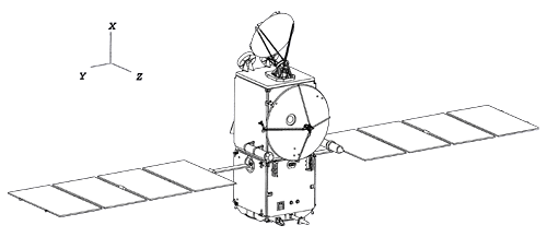
The fuel tanks on Jason have been designed and aligned so that the center of mass of the spacecraft as a whole only moves along the X direction during the satellite's life in orbit. By construction this is the X axis, so that the Y and Z coordinates of the center of mass in the spacecraft frame are always zero.

The table below gives the spacecraft mass first after deployment in orbit, then once 8 kg of hydrazine have been used. The expected cost of the station acquisition is around 5 to 6 kg. Both the spacecraft mass and center of mass location will be updated once in orbit, and throughout the life of the mission.

  Mass (kg) X center of mass (mm)
after deployment in orbit 489.1 935
minus 8 kg of hydrazine 481.1 942

This mass and center of mass are for the whole spacecraft, including the solar panels. For information, the solar panels' mass is 42.4 kg, and their center of mass is located on the X axis at 855 mm.

Attitude control

The attitude control law for Jason is identical to that of Topex/Poseidon. Its yaw motion is designed to keep the proper orientation of the solar panel rotation axis. Its pitch motion keeps the altimeter antenna pointed perpendicular to the reference ellipsoid.
When the angle of the Sun over the orbit plane is smaller than 15 degrees, the yaw rotations are stopped and the satellite is placed in fixed yaw. When the Sun crosses the orbit plane, the satellite reverses itself (flip).
Contrary to Topex/Poseidon, the transition between fixed and sinusoidal yaw modes for Jason should occur at well defined times. For each day of the cycle, there is an identified orbit when the transition can occur, close to the sub Solar point in order to minimize rotations. Thus it should be possible to predict when these tansitions will occur. In the short term, we will provide an Satellite Attitude Events File similar to the one for Topex/Poseidon. There might be a possibility to also provide quaternions in the future.

Macro-models

Macro-models for Jason have been derived from a detailed satellite description file provided by the manufacturer. These data were used to compute a micro-model for the spacecraft central body. Accelerations due to solar radiation were computed for all possible incoming light directions using this model. A simplified 6-face box model was then optimally adjusted to reproduce these accelerations as accurately as possible. As the box model was adjusted to the whole set of incoming directions it can be used for direct solar radiation pressure computation as well as for albedo computation.

The product of the surface by the optical coefficient is the only factor that matters in the computation of the accelerations. We used this degree of freedom to set the areas of the box model to the actual projected surfaces of the satellite, instead of applying the usual normalization which sets the sum of coefficients to 1. The advantage of this approach is that the same physical model can be used for drag and radiation forces. If your software requires normalized coefficients, just resize the surfaces!

Care was taken to include all effects in the model. In particular, the visible model takes into account the fact that the energy absorbed by the thermal blanket is completely reradiated at infrared wavelengths (it does not contribute to heating up the spacecraft). The visible properties of the blanket were modified to account for this effect. Additional details will be provided in a technical note.

For the solar arrays, SA+ corresponds to the face turned toward the Sun.

Jason visible
surfaces
X+ X- Y+ Y- Z+ Z- SA+ SA-
area
1.65 1.65 3.0 3.0 3.1 3.1 9.8 9.8
specular ref.
0.436 0.434 0.357 0.321 0.240 0.318 0.344 0.004
diffuse ref.
0.209 0.215 0.375 0.400 0.402 0.370 0.006 0.298
absorbed ref.
-0.001 0.005 0.271 0.308 0.330 0.267 0.647 0.697
Jason infra-red
surfaces
X+ X- Y+ Y- Z+ Z- SA+ SA-
area
1.65 1.65 3.0 3.0 3.1 3.1 9.8 9.8
specular ref.
0.425 0.408 0.334 0.274 0.236 0.298 0.097 0.035
diffuse ref.
0.178 0.186 0.342 0.369 0.382 0.336 0.098 0.035
absorbed ref.
-0.026 -0.012 0.249 0.297 0.309 0.240 0.803 0.931

In order to take in account the thermal emissivity in routine operation, resulting from the energy dissipated by the various instruments and radiated through the radiators, one has to add a constant bias force fixed with respect to the satellite's frame

emissivity  radiated power (W) force (µN)
Xs 40 -0.09
Ys 80 -0.18
Zs 0-8 0.0

Instruments phase centers

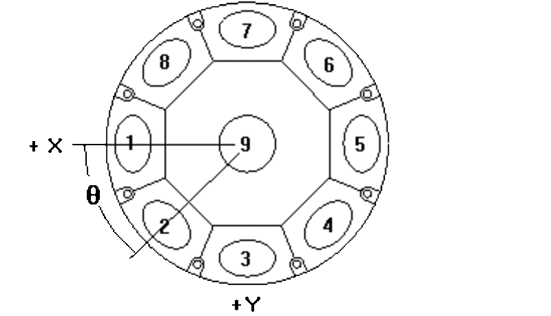
The phase centers of the various instruments of Jason are given below in the satellite frame

  X (mm) Y (mm) Z (mm)
Altimeter 1616.0 0.0 477.5
Doris 2GHz 1171.0 - 598.0 1027.0
Doris 400 MHz 1171.0 - 598.0 859.0
LRA (optical center) 1171.0 598.0 682.8
GPS 1 - L1 2408.0 219.7 -537.2
GPS 1 - L2 2420.1 220.7 -558.3
GPS 2 - L1 2408.0 -219.7 -537.1
GPS 2 - L2 2420.2 -220.8 -558.5

Doris

Note that for Doris, the export data is referenced to the 2 GHz frequency (the position of the 400 MHz phase center is not required). The two Doris receivers are connected to the same antenna.

GPS

For the Turbo-Rogue GPS Space Receiver, the two receivers are connected to independant antennas. The receiver that will be turned-on after launch is the 2. The GPS antennas are tilted with respect to the satellite's axes. The spacecraft relative phase locations are thus obtained by applying a rotation to the phase center positions measured relative to the antenna.

The following tables give the reference points of the GPS antennas with respect to the spacecraft, the rotation matrices going from the satellite's frame to the antenna frame, and the location of the phase centers in antenna frame.

reference points X (mm) Y (mm) Z (mm)
GPS 1 2370.5 216.4 -472.1
GPS 2 2370.5 -216.4 -472.1

rotation matrix from satellite frame to antenna frame for GPS 1

0.867 -0.025 0.497
0.000 -0.999 -0.050
0.498 0.044 -0.866

rotation matrix from satellite frame to antenna frame for GPS 2

0.867 0.025 0.497
0.000 -0.999 0.050
0.498 -0.044 -0.866

antenna phase center in antenna frame (along the antenna axis)

  Z (mm)
GPS 1 L1 75.2
GPS 1 L2 99.5
GPS 2 L1 75.1
GPS 2 L2 99.8

LRA

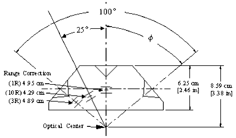
Here is the description of the LRA that we have received. We propose to use a constant correction of 4.9 cm to perform the first POD analyses.

 Image

Image


If you experience any problem processing the Jason data or understanding the spacecraft description, please contact:

CNES Precise Orbit Determination Group 
18 avenue E. Belin 
31401 TOULOUSE Cedex 4 
France

Details
Last Updated: 28 January 2025

IDS data structure and formats

The document is also available here

Details
Last Updated: 26 April 2019

Documents for the data analysis

It's very likely that the FTP protocol is not supported by your web browser.
The alternative is to use a FTP client such as WinSCP, FileZilla, MobaXterm.

Note that most of the files available at ftp://ftp.ids-doris.org/pub/ids/ can be seen at https://ids-doris.org/documents/BC/ too.

Here are gathered documents and input material useful for data and product users

Categories: General | DORIS system | Space segment | Ground segment | Observations | Products | Analysis: models


General

  • See IDS data structure and formats  for File naming conventions, Data Centers structure, Formats
  • See Outreach material for description of the DORIS system, leaflets, videos, newsletters
  • See Overview of the documentation for all links to the pages where the documentation provided by the IDS is stored.


The DORIS system

  • DORIS system definition 
  • DORIS system events: satellites, instruments, satellite control center, SSALTO (control and data processing center), ...


Space segment

  • The DORIS constellation: COSPAR numbers, Launch and Orbital information
  • Spacecraft ID correspondence table for orbit exchange file (SP3c code, NORAD number...)
Technical documents
  • Modelling of the DORIS instruments (description of measurement types; ground, propagation and onboard instrument models):  
    • 1G (Spot-2, -3, -4, Topex) and 2G (Envisat) 
    • 2GM (Spot-5, Jason-1) 
  • Macromodels:  DORIS satellites models implemented in POE processing 
  • DORIS USO sensitivity to radiations  
  • Cryosat-2 precise orbit context  
  • Cryosat-2 characteristics for DORIS calibration and POD processing  
  • HY-2A input data for Precise Orbit Determination 
  • HY-2C input data for Precise Orbit Determination 
  • Jason-1 postlaunch satellite characteristics for POD activities
  • Jason-2 satellite geometry  
  • Jason-3 characteristics for POD activities  
  • Saral characteristics for DORIS calibration plan and POD processing  
  • Sentinel-6A POD context 
  • Swot characteristics for POD processing 
  • Attitude laws of Swot and Sentinel-6 
Data files
  • Attitude:
    • Envisat (alt.: ftp://ftp.ids-doris.org/pub/ids/satellites/en1att.txt)
    • Jason-1 (alt.: ftp://ftp.ids-doris.org/pub/ids/satellites/ja1att.txt)
    • Jason-2 (alt.: ftp://ftp.ids-doris.org/pub/ids/satellites/ja2att.txt)
    • Jason-3 (alt.: ftp://ftp.ids-doris.org/pub/ids/satellites/ja3att.txt)
    • Sentinel-6A (alt.: ftp://ftp.ids-doris.org/pub/ids/satellites/s6aatt.txt)
    • Swot (alt.: ftp://ftp.ids-doris.org/pub/ids/satellites/swoatt.txt)
    • Topex (alt.: ftp://ftp.ids-doris.org/pub/ids/satellites/topatt.txt)
  • Quaternions:
    • Cryosat-2
      • TU Delft : ftp://dutlru2.lr.tudelft.nl/pub/ejo/cryosat2/quaternion/; description 
      • ESA: see here how to get access or contact This email address is being protected from spambots. You need JavaScript enabled to view it.; documentation: algorithm description , product format specifications 
    • Jason-1 (CDDIS, IGN: ftp://doris.ign.fr/pub/doris/ancillary/quaternions/ja1)
    • Jason-2 (CDDIS, IGN: ftp://doris.ign.fr/pub/doris/ancillary/quaternions/ja2)
    • Jason-3 (CDDIS, IGN: ftp://doris.ign.fr/pub/doris/ancillary/quaternions/ja3), documentation 
    • Sentinel-3A&B and Sentinel-6A (Copernicus Sentinels POD data hub)
      • format description (extract); 
      • CPOD format specification; 
      • API user guide;
      • example of API request
    • Swot body quaternions and solar panel angles (CDDIS, IGN: ftp://doris.ign.fr/pub/doris/ancillary/quaternions/swo), 
      • documentation quaternions 
      • documentation solar panel angles
  • Maneuvers:  description file
    • Cryosat-2 (alt: ftp://ftp.ids-doris.org/pub/ids/satellites/cs2man.txt) 
      • time frames when nominal attitude law off (ftp://thales.lr.tudelft.nl/pub/ejo/cryosat2/quaternion/attlaw.d); see description )
    • Envisat (alt: ftp://ftp.ids-doris.org/pub/ids/satellites/en1man.txt)
    • HY-2A (alt: ftp://ftp.ids-doris.org/pub/ids/satellites/h2aman.txt)
    • HY-2C (alt: ftp://ftp.ids-doris.org/pub/ids/satellites/h2cman.txt)
    • HY-2D (alt: ftp://ftp.ids-doris.org/pub/ids/satellites/h2dman.txt)
    • Jason-1 (alt: ftp://ftp.ids-doris.org/pub/ids/satellites/ja1man.txt)
    • Jason-2 (alt: ftp://ftp.ids-doris.org/pub/ids/satellites/ja2man.txt)
    • Jason-3 (alt: ftp://ftp.ids-doris.org/pub/ids/satellites/ja3man.txt)
    • Saral (alt: ftp://ftp.ids-doris.org/pub/ids/satellites/srlman.txt)
    • Sentinel-3A (alt: ftp://ftp.ids-doris.org/pub/ids/satellites/s3aman.txt)
    • Sentinel-3B (alt: ftp://ftp.ids-doris.org/pub/ids/satellites/s3bman.txt)
    • Sentinel-6A (alt: ftp://ftp.ids-doris.org/pub/ids/satellites/s6aman.txt)
    • Spot2 (alt: ftp://ftp.ids-doris.org/pub/ids/satellites/sp2man.txt)
    • Spot3 (alt: ftp://ftp.ids-doris.org/pub/ids/satellites/sp3man.txt)
    • Spot4 (alt: ftp://ftp.ids-doris.org/pub/ids/satellites/sp4man.txt)
    • Spot5 (alt: ftp://ftp.ids-doris.org/pub/ids/satellites/sp5man.txt)
    • Swot (alt: ftp://ftp.ids-doris.org/pub/ids/satellites/swoman.txt)
    • Topex (alt: ftp://ftp.ids-doris.org/pub/ids/satellites/topman.txt)
  • Mass and gravity center initial values recommended by IDS (alt: ftp://ftp.ids-doris.org/pub/ids/satellites/MassCoGInitialValues.txt)
  • Mass and gravity center history:  description file
    • Cryosat-2 (alt: ftp://ftp.ids-doris.org/pub/ids/satellites/cs2mass.txt)
    • Envisat (alt: ftp://ftp.ids-doris.org/pub/ids/satellites/en1mass.txt)
    • HY-2A (alt: ftp://ftp.ids-doris.org/pub/ids/satellites/h2amass.txt)
    • HY-2C (alt: ftp://ftp.ids-doris.org/pub/ids/satellites/h2cmass.txt)
    • HY-2D (alt: ftp://ftp.ids-doris.org/pub/ids/satellites/h2dmass.txt)
    • Jason-1 (alt: ftp://ftp.ids-doris.org/pub/ids/satellites/ja1mass.txt)
    • Jason-2 (alt: ftp://ftp.ids-doris.org/pub/ids/satellites/ja2mass.txt)
    • Jason-3 (alt: ftp://ftp.ids-doris.org/pub/ids/satellites/ja3mass.txt)
    • Saral (alt: ftp://ftp.ids-doris.org/pub/ids/satellites/srlmass.txt)
    • Sentinel-3A (alt: ftp://ftp.ids-doris.org/pub/ids/satellites/s3amass.txt)
    • Sentinel-3B (alt: ftp://ftp.ids-doris.org/pub/ids/satellites/s3bmass.txt)
    • Sentinel-6A (alt: ftp://ftp.ids-doris.org/pub/ids/satellites/s6amass.txt)
    • Spot2 (alt: ftp://ftp.ids-doris.org/pub/ids/satellites/sp2mass.txt)
    • Spot3 (alt: ftp://ftp.ids-doris.org/pub/ids/satellites/sp3mass.txt)
    • Spot4 (alt: ftp://ftp.ids-doris.org/pub/ids/satellites/sp4mass.txt)
    • Spot5 (alt: ftp://ftp.ids-doris.org/pub/ids/satellites/sp5mass.txt)
    • Swot (alt: ftp://ftp.ids-doris.org/pub/ids/satellites/swomass.txt)
    • Topex (alt: ftp://ftp.ids-doris.org/pub/ids/satellites/topmass.txt)
  • SAA corrective model: Jason-1
Laser Reflector Array offset (ILRS)

Table of coordinates and details for: 

  • Cryosat-2
  • Envisat
  • HY-2 (other ILRS links hy-2a, hy-2c, hy-2d )
  • Jason-1
  • Jason-2
  • Jason-3
  • Saral
  • Sentinel-3A
  • Sentinel-3B
  • Sentinel-6A
  • Swot
  • Topex


Ground segment

  • Modelling of the ground beacons and ground antennas  
  • Geometry and types of ground antenna 
    • Examples of the two types of antennas: Galapagos (Alcatel), Santa Cruz (Starec) 
  • DORIS site standard configurations 
  • System requirements for management of the DORIS station network  
  • Station managment
  • Interface specification between the DORIS network beacons and the onboard instrument (extract) 
  • About DORIS stations equipment and impact on the frequency 
  • Radio-frequency characteristics of the DORIS beacon  
  • Frequency shift mode of the 3rd and 4th generation beacons    
  • Recommendations on the phase laws implementation for types B and C
  • Antenna phase laws in antex format  
    • see readme
    • for Alcatel ground antenna
    • for Starec ground antenna, types B and C
Characteristics of the DORIS sites
  • Site logs
  • SINEX master file : stations IDs (codes, DOMES), antenna type, eccentricity
  • File of the station frequency shifts
  • List of stations with external time and frequency references
Ties
  • DORIS internal ties: vectors between different antennas on the same site
  • DORIS ties with other IERS techniques: vectors from DORIS to co-located GNSS, SLR or VLBI since 1988.
Station events
  • See the Table of the system events for: 
    • Chronology of the main events that occurred on the DORIS station network (new sites, new antennas, removed sites, failures...) with information on data gaps, invalidated data...
    • List of the Earthquakes with magnitude larger than 6 in the vicinity of DORIS sites (less than 500 km) - based on USGS Earthquake notifications 
More information 
  • Colocated sites with GPS, SLR, VLBI and tide gauges: see Maps here
  • About the DOMES Number the IERS/TRF station naming system. See the IDS FAQ
  • Local surveys: some reports online on ITRF website


Observations

Technical documents
  • About DORIS/RINEX format
  • Description of CNES/SOD POE processing
  • Description of the CNES/SOD preprocessing  for the DORIS data export formats (June 2002).
  • Detailed standards of the successive CNES/SOD POD configurations defined for the Geophysical Data Records (GDRs) altimetry products and applied for the DORIS satellites :
    • GDR-B (2005) 
    • GDR-C (2008) 
    • GDR-D (2012) 
    • GDR-E (2015) (also named POE-E) 
    • POE-F (2018) 
    • POE-G (2025) 
 DORIS data export formats
  • DORIS 1b (preprocessed  data)
    • DORIS 1.0 (before January 2002), 
    • DORIS 2.1
    • DORIS 2.2 (since June 2008)
  • RINEX/DORIS (raw data) 

List of DORIS1b files available for satellite (correspondence table "cycle or arc" and "start date - end date"

  • Cryosat-2 (mission in operation)
  • Envisat 
  • HY-2A 
  • Jason-1
  • Jason-2
  • Saral (mission in operation)
  • Spot2
  • Spot3
  • Spot4
  • Spot5
  • Topex


The products and their availability

  • What kind of product and where to find them? See IDS data structure and formats
  • Table of products
  • Products of the Combination Center
Formats
  • SINEX format: description; exemple
  • Orbits: sp1 format, sp3 format, sp3c extended format; more details in NOAA Technical Report NOS 113 NGS 46 (full document  - 22 Mb, extract )
  • Time series of the Earth Orientation Parameters (EOP) - eop format
  • Time series of station coordinates - STCD format 
  • Time series of coordinates of the TRF origin (geocenter) - geocenter format
  • Ionosphere - iono format 


Analysis: some models

  • Set of coordinates and velocities of all DORIS stations (extension of the ITRF for Precise Orbit Determination) available at CDDIS and IGN (ftp://doris.ign.fr/pub/doris/products/dpod/)
    • DPOD2020 (based on ITRF2020) - Produced by IDS Combination Center
    • DPOD2014 (based on ITRF2014) - Produced by IDS Combination Center
    • DPOD2008 (based on ITRF2008)
    • DPOD2005 (based on ITRF2005)
    • DPOD2000 (based on ITRF2000) 
  • ITRF solutions: ITRF2020, ITRF2014, ITRF2008, ITRF2005, ITRF2000, and others 
  • Earth Orientation Parameters at IERS EOP product center
  • Ocean tide models FES (FES99, FES2004, FES2012, FES2014, FES2022)
  • Gravity field: GRGS time variable models from GRACE/SLR (EIGEN-6S4 and others) and GFZ/GRGS EIGEN mean models at GRGS (e.g. CNES_GRGS.RL05MF_combined_GRACE_SLR_DORIS)
  • Gravity field: GRACE websites at GFZ Potsdam and CSR Austin
  • Drag temperature model: DTM-2020 (SWAMI project)
  • Atmospheric density model: NRLMSIS 2.0 (model website)
  • Local corrections: see IERS Global Geophysical Fluids Center (GGFC) Special Bureaus.
  • Troposphere delay corrections from TU Wien
Technical documents
  • IERS Conventions: reference systems and frames, astronomical and geophysical models (Conventions updates, Conventions 2010, Conventions 2003, ...)
  • IDS recommendations for ITRF2004 : specific document for Combination Centers describing major DORIS-station related problems (November 2005) - Annexes 

 
Details
Last Updated: 15 May 2025
  • Section content
  • Table of system events
  • Day convertor
  •  Network viewer Network viewer
  •  Plot tools Plot tools
    • Station position
    • Position residuals
    • Orbit residuals
    • Combination parameters
    • Earth Orientation Parameters
  • Applications
  • Combination Center
    • Activity & Products
    • Cumulative solution
    • DPOD
    • Contributions to ITRF
  • About DORIS/RINEX format
Feed Entries

Discover IDS

  • Organization
  • Table of Data & Products
  • Bibliography
  • Newsletter
  • IDS video channel
  • Presentations at IDS meetings
  • Technical documents
  • Activity reports

Discover DORIS

  • The DORIS technique (AVISO+ website)
  • The satellites
  • The network
  • The stations (sitelogs)
  • Network on Google Earth

DORIS system monitoring

  • Table of system events
  • Visualize products time series
  • POE statistics
  • Network viewer
ICSU-WDS
ICSU-WDS
ICSU-WDS


logo cnes

Site Map |  Contact |  Citation |  Mails |  FAQ |  Glossary
Personal Data Protection Policy |  Legal Notice
Copyright © 1999-2025 CNES-CLS. All Rights Reserved.